This blog is not for profit or political

Tuesday, July 18, 2023

Moderating Heat & a Chance of T-Storms Across Utah

The last couple of days were the hottest so far this summer in Salt Lake City and much of Utah. The SLC airport hit 106F Sunday and 105F Monday, just below the all-time high of 107F. If you want some relief from the heat, you're in luck!


A weak front moved into Utah last night bringing slightly milder air, and a bit of moisture as well. Satellite imagery this morning shows this clearly, with the main band of limited clouds across the North Central part of the state. My friend in Broomfield, Colorado is likely waking up to sunny skies, lucky him! Here in Utah, there's a mix of mid-high clouds but some sunshine as well. 


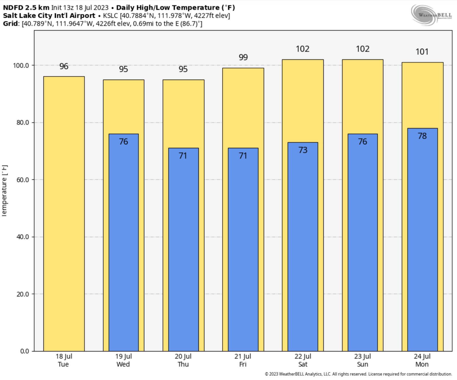
So, let's talk temperatures first. The Salt Lake area can expect high temperatures about 10 degrees cooler than Monday. That's nice! Temperatures will remain moderated the next couple days until this lingering front moves on. Then, yes, a warmup! Here's the National Weather Service forecast highs for Salt Lake City into the weekend.


Now for the potential for showers and thunderstorms. The central and south part of the state have the highest likelihood of brief heavier thundershowers. This is due to the best dynamics along the residual front just south of the Wasatch front.

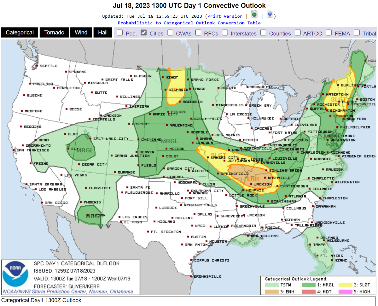
However, moisture will increase aloft across Northern Utah as well, giving a chance of dry thunderstorms initially, then perhaps some precipitation. This is a recipe for strong thunderstorm downburst winds. First off, here's the Storm Prediction Centers convective outlook for today. There's a slight to moderate risk over parts of Utah. 


The almost classic inverted-V sounding is evident on the SLC morning sounding which measures temperatures, winds, and humidity (and more) through the atmosphere in the vertical. The dew point and temperatures lines are far apart below 500 mb, which is dry. Thy are closer above 500 mb indicating more moisture. If convection (thunderstorms) deveop, precipitation falling into the dry layer will accelerate downward, resulting in a gusty wind potential. It's not a given, but a potential later today.


While dry outflow winds are likely at the start, eventually the lower levels will moisten up. Dry thunderstorms will transition to wet thunderstorms, especially over central and southern areas where moisture is deeper. The SLC National Service issued this graphic to show where some heavier rainfall could cause flash flooding. This is not a major even but still dangerous for those unaware and engaging in outdoor activities in flood prone areas. 


The shower and thunderstorm threat decreases Thursday into Friday. Hotter and dry weather likely this weekend. Current forecast information is available at 
Salt Lake City, UT (weather.gov)

Sunday, March 27, 2022

Mini Heat Wave Across Utah, with a Transition to Cool & Wet Weather

It was a rather warm day across the state of Utah today. Sunday looks to be a repeat, then changes are on the way. Here's a round up of the high temperatures Saturday:


Records fell, including at the SLC airport. It reached near 90 in parts of the St. George area.


Before we get to the outlook, let's take a glance at where the SLC airport stands with regard to precipitation and snowfall for the water year (Oct 1st - current):


As you can see, precipitation is very close to average to date for the water year. It's hard to believe, but the very wet October and December last year really saved the season. Snowfall is roughly 5" short of the 30-year average. Now that's the valley, what's really important is snowpack or snow water equivalent (SWE) across the mountains in Utah. It determines how much our reservoirs fill for the summer.


Not good, much of the state is only 3/4 of average. That's coming off a very dry previous year and low reservoir levels. Expect worse reservoir levels this summer than last year, especially up north. It could be worse, but really we need above average snowpack to get some relief. And just for reference, Alta Ski Resort is at 352" for the year. They average 80" for the month of April, but even if they get that, they will very likely end below average for snowfall this season. 

We do have one more dry, warm day across the state, then things will begin to change. As for temperatures, here's the forecast at SLC for the week:


You can see we have cooler air on the way Tuesday, behind a front. And some rain is expected, although generally light. Here's the rainfall total projection through the next week:


Most of the rain will fall Tuesday into Wednesday, and perhaps a little next weekend. These weak systems won't be a big snow producer for the higher mountains, but several inches of fresh snow is likely at the ski areas. That's something, but not what we need. 

Beyond the week, is there hope for bigger rain/snow amounts for Utah? The Climate Prediction Center does not think there's a great chance. They are going for above average temperatures and near average precipitation in the 8-14 day outlook. Bummer, hope that changes.


Saturday, March 5, 2022

Heavy Snow Possible in Some Wasatch Front Valleys Tonight & Sunday

I'm increasingly excited about a storm currently moving into Utah tonight. It is arriving from off the Pacific, so it contains moisture-laden air, in contrast to most our storms since January. As colder air arrives through the evening, rain will transition to snow across nearly all I-15 valleys, except the far south. As always, the devil is in the details. I will get to the valley snow potential in a moment. 

First, I should mention most valleys have fallen behind in snowfall and liquid precipitation for the current water year (Oct 1st, 2021 to end of Sept 2022). 

Salt Lake City International Airport has not received 2" or more of daily snowfall since 3.6" fell on December 31st, 2021. I can only think of one word-- Ugh! Okay, two words-- Abysmal!

Take a look at the water year statistics for the Salt Lake City Airport:


The airport has fallen below average on precipitation, most of which fell in October and December of last year. Snowfall is running less than 2/3 of average, 27.7" as of March 4th. 

I wonder how the north-end of the Wasatch Front is faring with snow? Take a look at Logan, Utah:


Current seasonal snowfall (green line) is only at 75% of average (brown line). The same can be said for Provo, Nephi and many other valleys along the I-15 corridor south to Cedar City. 

Even if we have an active March, it will be extremely difficult to end the year with even near-average snowfall. Storms tend to deliver lighter snow amounts in the valleys (and mountains) as we progress through the month.

Now, let's assess the upcoming storm. The water vapor satellite loop, overlaid with the upper level low, is a good place to start:


An important feature to recognize, is the bright moisture band lifting NE into Utah ahead of the low center. For more intense precipitation rates (rain or snow), you need strong lift. Notice, the upper level divergent (or diffluent) winds, spreading out, as evident by the direction of the arrows. This "stretching" aloft, allows dense air below to rise. As the air cools and condenses,  precipitation falls.

Air can be lifted in other ways as well. Here is another area of lift caused by low level convergence:


Notice, surface low pressure is drawing wind flow in from the north and south. This is referred to as "frontogenesis" by meteorologists. The colliding air at the surface can only go in one direction, and that's up! So, additional lift, good for heavier precipitation.

Lift and moisture are currently coming together over northern Utah. An intense band of rain is developing, and even some embedded thunder. The faster rain switches to snow in valleys, the higher amounts are likely to be. The heaviest snow is expected to fall from around 10 pm tonight to 10 am Thursday, give or take.


Model ensembles are helpful for looking at potential snow amount ranges for SLC. These are 50 runs of the same model to give a range of outcomes. It's helpful for looking at low, average, and higher-end estimates. This is a point forecast for SLC only!


Focus on the green line, which is the average through Sunday afternoon. It indicates close to 4" at the airport. I might knock off 1" if snow doesn't start to accumulate by 10 PM. The ground is warmer this time of year, after all. 

The National Weather Service is a government forecast entity. I consider their forecasts, as "official" vs. TV or weather apps. Here's their forecast:


The National Weather Service looks at all the variables, and devise with their own forecast. Sometimes they are closest (compared to private sources), other times not. They're going 4-6" from SLC to Ogden. 6-8+ inches benches. Less to the south in Utah County, and also areas north of Ogden. That's very reasonable. 

One more model to evaluate is the University of Utah, down-scaled version of the GFS. The higher resolution picks up smaller-scale weather features and terrain influences. It puts a sloth of 4-8 inches across the entire Salt Lake Valley through Sunday morning. This is further south than most other models, which put the heaviest amounts from the north-end of the Salt Lake Valley to around Ogden.


We won't know much more until we look out the window Sunday morning. Snow should continue into the early afternoon hours, and begin to taper off. Areas east of I-15, benches, and mountains could still get meaningful accumulation Sunday afternoon. Increasing NW flow could still squeeze out 1-2" due to orographic (or terrain) lift in those areas. Up to 2 feet could fall in total at some favored Ski Resorts.   

Thursday, March 3, 2022

Record Warmth, Followed by Winter-Like Weather this Weekend.

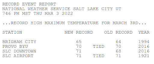
Some locations in Utah experienced the warmest temperatures of the year today, especially the central and south portions of the Wasatch Front Valleys. Spots around Salt Lake and Utah Counties even reached the low 70s! These highs were similar to what the St. George area experienced. 


In fact, it was record warm in Salt Lake and Provo. This is the record report issued by the National Weather Service:


Remember, spring doesn't arrive until March 20th! The average high/low temperature for SLC is only 51F/33F. 

Winter weather continues to be largely missing-in-action for the West. Mountain snowpack is generally not faring well at this point. At least, we appear to have a "little" help on the way. Not a blockbuster storm. I am anticipating cooler and wetter weather for parts of the Southwest/Great Basin this weekend. Good news! 

Here's the accumulated rainfall forecast for the next 7 days. Most precipitation will fall through this weekend. Utah could receive some of the highest precipitation amounts, with a separate system around the middle of next week boosting totals.


Converting liquid to snowfall for higher elevations (10:1 ratio), implies around 1 foot over the Sierras, and 1-2 feet in Utah's Mountains. Colorado may also do quite well. What about Utah's Valleys, including the Wasatch Front?

Gradual cooling is expected Saturday into Saturday night, with about half the precipitation falling as rain on Saturday. As the low crosses the area late Saturday night and Sunday, snow is expected along the I-15 corridor in Utah, from near Cedar City northward. And, some of the highest snow totals could fall across the northern valleys. Here's a look at the upper low track:


A deformation band (region of lift in the mid/upper atmosphere), north of the low center, could produce more intense rain/snowfall. Here's a look at moisture in the vertical, reading left to right at bottom, through time at SLC. Notice the more intense blue/purple colors "higher moisture" in the lowest levels early Sunday, as the deformation zone "or lift" is in over northern Utah.


Model ensembles are often useful when looking beyond a couple of days. These are multiple runs of the same model, giving a potential range of outcomes. What do the ensembles show for SLC? Focus on the green line, which is the average of all the runs. There will always be high and low outliers. I mostly ignore these individual runs. 


As you can see, the green "average" line of 24-hour snowfall produces about 2-3" for Salt Lake City Saturday night through Sunday. Not bad for a March storm, if it comes to pass. 

In addition, another storm is shown for Thursday of next week. This system appears a bit weaker, and fast moving. But, also colder with favorable NW flow. I can easily see a couple inches for the northern Utah valleys. Sorry southern Utah friends, this one will likely miss you! 

I will probably be unable to post for the next 10 days or so. Check the SLC Weather Service site for updated weather info! I also have links on my blog to road conditions and other resources. Have a great week, everyone! Fingers crossed for some decent mountain snow!

A Vigorous Cold Front & Snow Expected Monday Night into Tuesday.

The current El Nino winter has brought plenty of precipitation to Utah. Most areas are above average on liquid water since October 1st, incl...