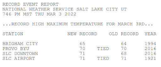
Some locations in Utah experienced the warmest temperatures of the year today, especially the central and south portions of the Wasatch Front Valleys. Spots around Salt Lake and Utah Counties even reached the low 70s! These highs were similar to what the St. George area experienced.
In fact, it was record warm in Salt Lake and Provo. This is the record report issued by the National Weather Service:
Remember, spring doesn't arrive until March 20th! The average high/low temperature for SLC is only 51F/33F.
Winter weather continues to be largely missing-in-action for the West. Mountain snowpack is generally not faring well at this point. At least, we appear to have a "little" help on the way. Not a blockbuster storm. I am anticipating cooler and wetter weather for parts of the Southwest/Great Basin this weekend. Good news!
Here's the accumulated rainfall forecast for the next 7 days. Most precipitation will fall through this weekend. Utah could receive some of the highest precipitation amounts, with a separate system around the middle of next week boosting totals.
Converting liquid to snowfall for higher elevations (10:1 ratio), implies around 1 foot over the Sierras, and 1-2 feet in Utah's Mountains. Colorado may also do quite well. What about Utah's Valleys, including the Wasatch Front?
Gradual cooling is expected Saturday into Saturday night, with about half the precipitation falling as rain on Saturday. As the low crosses the area late Saturday night and Sunday, snow is expected along the I-15 corridor in Utah, from near Cedar City northward. And, some of the highest snow totals could fall across the northern valleys. Here's a look at the upper low track:
A deformation band (region of lift in the mid/upper atmosphere), north of the low center, could produce more intense rain/snowfall. Here's a look at moisture in the vertical, reading left to right at bottom, through time at SLC. Notice the more intense blue/purple colors "higher moisture" in the lowest levels early Sunday, as the deformation zone "or lift" is in over northern Utah.
Model ensembles are often useful when looking beyond a couple of days. These are multiple runs of the same model, giving a potential range of outcomes. What do the ensembles show for SLC? Focus on the green line, which is the average of all the runs. There will always be high and low outliers. I mostly ignore these individual runs.
In addition, another storm is shown for Thursday of next week. This system appears a bit weaker, and fast moving. But, also colder with favorable NW flow. I can easily see a couple inches for the northern Utah valleys. Sorry southern Utah friends, this one will likely miss you!
I will probably be unable to post for the next 10 days or so. Check the SLC Weather Service site for updated weather info! I also have links on my blog to road conditions and other resources. Have a great week, everyone! Fingers crossed for some decent mountain snow!


No comments:
Post a Comment
Only posts from Gmail accounts will be reviewed and posted. Thank you!