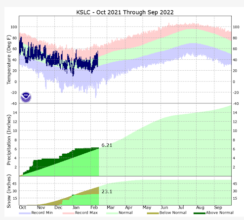
Since early January, the weather out West can only be described as, well-- blah! High pressure rules, with only occasional weak storms. This is in stark contrast to the wet, cold and snowy weather across the region last December. We need more weather!
Well, I have some good news to share on that front. We have a couple of cold weather systems, that will affect areas from the Pacific Northwest to the interior West through at least the middle of next week. The initial system can be seen on water vapor satellite imagery moving into the Northwest today:
You can see the moisture trajectory coming from British Columbia. This means cold air will be driving into the West, along with precipitation. Because this system is not coming directly off the Pacific, the extent of snowfall across the West will be somewhat limited. The Sierra Mountains will largely miss out-- boo!
Anytime it's cold enough for lowland snow in Western Washington, I get excited. Often, this portends good things for snow here in Utah. To get snow down to sea-level in the Puget Sound region, a high amplitude ridge is required over the East Pacific with a trough (usually) from the north. Here is the 500 MB pattern on Monday, showing this will be the case:
It's getting late in the year for accumulating snow in the Seattle area, but I do think mixed precipitation is possible in heavier showers Monday. Those living on hilltops, along the Kitsap and Strait, and where a convergence zone forms (typically north of Seattle), could see a dusting on the grass. The Euro model agrees:
Generally, less than 1 inch.
It will also be darn right cold for late February! Take a look at the forecast temperatures for Sea-Tac Airport:
Burr! So, where is this storm heading?
It will actually move into the Great Basin/Southwest in two parts. The first system will reach the Wasatch Front Monday morning and push into the south part of the state later in the day. Some models show potential strengthening (referred to as "frontogenesis"), which could locally boost snow amounts. Here is a model simulation showing the main snow band and developing low pressure:
The Euro model forecast snow amounts for the first storm appear reasonable, shown below. Not a lot, maybe 1-2" in the valleys, a bit more benches, and ~6 inches in the higher mountains through Monday night. Similar amounts are expected further south along the I-15 corridor. Expect the potential for snowy roadways if traveling in Utah on President's Day. Also, check the latest forecast from the NWS.
The second storm system will track further south across Southern Nevada and Utah Tuesday through late Wednesday. Snow levels may fall as low as 2500 feet, meaning the outskirts of the Las Vegas Valley could see some flurries Wednesday. Yup- a few flakes could fly in higher spots like Summerlin and Henderson. However, don't expect any accumulation this late in the season.
Other low spots may have better luck! The two main forecast models (GFS/Euro) indicate some accumulation is possible in St. George. Most guidance suggests around one inch could fall Wednesday, mainly in the morning. Here's what the Euro model shows for that region, including Las Vegas:
You can see some trace amounts around Las Vegas, and just over 1" in St. George through Wednesday night. The weather is always probability based, so amounts could be a bit higher or lower in St. George. This is several days out, so keep that in mind!
The second system will likely hit the central and southern parts of Utah the hardest Tuesday through Wednesday night. Snow amounts south of Nephi could be significant, including Cedar City and higher locations like Brian Head Ski Resort. Amounts across Northern Utah will probably remain rather light, unless we get some lake effect kicking in. Check back as we get closer!
Finally, what about temperatures? Expect a big drop! Here's the NWS forecast for St. George:
Expect moderating temperatures and a drying trend later next week! Have a great holiday, and travel safely!


