It was a rather warm day across the state of Utah today. Sunday looks to be a repeat, then changes are on the way. Here's a round up of the high temperatures Saturday:
Records fell, including at the SLC airport. It reached near 90 in parts of the St. George area.
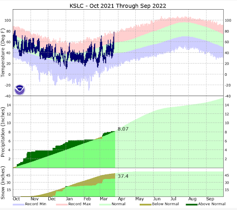
Before we get to the outlook, let's take a glance at where the SLC airport stands with regard to precipitation and snowfall for the water year (Oct 1st - current):
As you can see, precipitation is very close to average to date for the water year. It's hard to believe, but the very wet October and December last year really saved the season. Snowfall is roughly 5" short of the 30-year average. Now that's the valley, what's really important is snowpack or snow water equivalent (SWE) across the mountains in Utah. It determines how much our reservoirs fill for the summer.
Not good, much of the state is only 3/4 of average. That's coming off a very dry previous year and low reservoir levels. Expect worse reservoir levels this summer than last year, especially up north. It could be worse, but really we need above average snowpack to get some relief. And just for reference, Alta Ski Resort is at 352" for the year. They average 80" for the month of April, but even if they get that, they will very likely end below average for snowfall this season.
We do have one more dry, warm day across the state, then things will begin to change. As for temperatures, here's the forecast at SLC for the week:
You can see we have cooler air on the way Tuesday, behind a front. And some rain is expected, although generally light. Here's the rainfall total projection through the next week:
Most of the rain will fall Tuesday into Wednesday, and perhaps a little next weekend. These weak systems won't be a big snow producer for the higher mountains, but several inches of fresh snow is likely at the ski areas. That's something, but not what we need.
Beyond the week, is there hope for bigger rain/snow amounts for Utah? The Climate Prediction Center does not think there's a great chance. They are going for above average temperatures and near average precipitation in the 8-14 day outlook. Bummer, hope that changes.


No comments:
Post a Comment
Only posts from Gmail accounts will be reviewed and posted. Thank you!