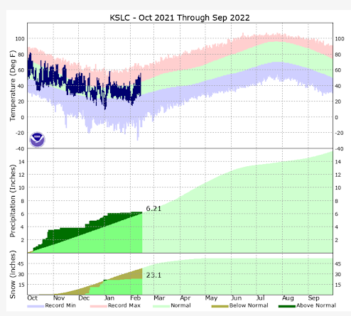
The weather pattern continues to disappoint this month, after measly January precipitation. It's hard to believe, but the Salt Lake Airport is still near average on water year liquid precipitation (Oct 1st 2021-Current). We've had some ups and downs with temperatures in the valleys, but we are generally running above average. Much of our seasonal precipitation fell in the months of October (when rain is more typical than snow in valleys), and in December, when the airport picked up almost all the snow that's fallen this season. Here's where we stand:
We should be near 38" at the Salt Lake Airport by this date, but we're only at 23.1", not great. More importantly, the lack of additional mountain snowpack is starting to get serious. As we move into March and April, average mountain snowfall trends start to decline. We are running out of time! Here's the latest snow water equivalent map (SWE) showing the decline to below normal across Utah and interior West as of today. We were well above normal at the start of January.
With that bit of bad news, we do finally have a chance of snow showers returning to parts of Utah tonight and Wednesday as colder air arrives. We may not reach out of the upper 30s Wednesday after hitting 60F at the Salt Lake Airport on Monday. First, here's a nice look at the water vapor satellite image (shows moisture, not clouds) with the 500 MB chart overlaid.
Those with a sharp eye might notice one obvious problem with the track of the upper low. Instead of diving south over Utah, the low is over Nevada/California. And the southern track is forecast to continue Wednesday. Here's what the Euro model shows:
While the main low tracks well south, notice a trailing upper trough (blue anomalies) hanging further back over Utah. This will be the weak system that ushers in colder air and limited moisture from late this evening through Wednesday. Since moisture and lifting of air is weak, snow showers should be light in nature. Here's a time-height of moisture in the vertical through time, reading left to right. You can see the deeper purples (moisture) developing.
Wondering how this showery pattern might evolve? The NAM model forecast simulated radar depicts this well. It runs from this evening through Wednesday PM.
Not a lot of solid blue, and snow is scattered in nature. This will limit snow amounts in the valleys. The National Weather Service forecast is often based closely on the NBM (blended model) forecast. I think it looks reasonable. Less than 1 inch in most Wasatch Front Valleys, and a few inches in the mountains (locally 6" at higher ski resorts). Don't be surprised to see a dusting on the grass Wednesday morning. Not the type of snow amounts we need!
So, is there a still a chance of ending February with a stronger storm? There is a system advertised by models around Monday-Tuesday next week. But, models do not yet agree on whether this will be a stronger system, or another weak splitting trough. I'm leaning toward a weaker system, although it could still deliver a little more snow than the current system. This is the Euro 500 MB trough forecast early next week:
There's potential for a storm by Monday or Tuesday. The elongated trough implies it could split, and may form a cut-off low. Not my favorite set-up, but it can sometimes surprise. How the upper air pattern evolves will determine the impact of the storm on Utah-- Stay tuned! I will discuss what could be in store as we head towards March in my next post.


No comments:
Post a Comment
Only posts from Gmail accounts will be reviewed and posted. Thank you!