High pressure has dominated the Western U.S. over the past week, with little active weather. Unfortunately, this strong upper ridge is largely expected to persist over the West through the next 10 days. Here is the forecast total rainfall estimate for that period. Notice the lack of precipitation over California, and interior West, including Utah. The Pacific Northwest is often the exception, and as expected, the jet stream does bring periods of rain to Washington and Oregon. It would not be surprising if there was some flooding on rivers west of the Washington Cascade Mountain crest.
The CPC (Climate Prediction Center) also agrees on this extended period of above normal temperatures and below normal precipitation for the West. They take it even further, and indicate this to persist during the 8-14 outlook period:
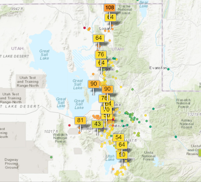
When the weather is quiet here in Utah, there is still usually something to talk about. The far extended outlook offers just that, some hope that we might indeed see a change in the weather pattern across our region. We'll get to that in a moment. Currently, stagnant conditions with valley inversions are in place over Utah. Just look at the view from the U of U showing valley haze due to inversions. Air quality is mostly in the moderate category-- unhealthy for sensitive groups.
Now that I have depressed the Utah weather enthusiasts with a dry 10 day outlook likely, here's some good news. I have watched the far extended model runs for several days now, and they generally indicate what I would refer to as a retrograding long wave pattern. What the heck is that? There are long wave ridges and troughs all across the hemispheres. A long wave trough is basically a region where individual storms will develop and track, and are usually indicative of an active storm pattern. So, not just one storm, but typically many individual storms that give a period of colder and wet or snowy weather. A long wave ridge provides the opposite-- a period of dry and warmer temperatures. What does this long wave pattern look like this next week? Here it is:
Colder and wintry weather across the Eastern U.S. and mainly dry and milder in the West. This does not show any individual storm, such as the rain affecting the Pacific Northwest. It shows the area where a mostly dry pattern is set up (over the West) and where colder, unsettled weather is persistant (over the East). I'm interested on when this will change, as these long waves shift very slowly over several days and weeks. And I see something good in the far extended models-- a retrograding long wave pattern. First, an initial system could graze Utah just beyond the 10 day period. This is not the big shift just yet, but rather a weak individual system that could bring a minor amount of precipitation and cooler air. Here's the Euro ensemble for SLC (50 runs at once giving an average of the different outcomes). It gives a hint that we might see something around roughly the 22nd of January. The bottom green line (average of all runs) shows up to a tenth of one inch of precipitation-- not significant!
When might we see significant winter weather reaching Utah and the greater Western U.S.? The CFS model (and other far extended models) are generally showing the long wave trough to shift westward toward the end of this month. Our chances for storms will increase at this point.
Looks more impressive for the first week of February, right! Since long waves move slow, this active pattern could potentially last into the second week of next month. That's very far out in time, so I can't go into further details. It simply appears more likely than not, that wintry weather returns to the West in early February. By mid to late February, there's not a good signal to indicate where the long wave trough will reside. Since long waves prefer the East coast over the West, I suspect less activity for the second part of the month. This large scale pattern change takes time to evolve, so we will all have to be patient-- yes skiers and snow lovers, I'm talking to you!


No comments:
Post a Comment
Only posts from Gmail accounts will be reviewed and posted. Thank you!