This blog is not for profit or political

Saturday, March 5, 2022

Heavy Snow Possible in Some Wasatch Front Valleys Tonight & Sunday

I'm increasingly excited about a storm currently moving into Utah tonight. It is arriving from off the Pacific, so it contains moisture-laden air, in contrast to most our storms since January. As colder air arrives through the evening, rain will transition to snow across nearly all I-15 valleys, except the far south. As always, the devil is in the details. I will get to the valley snow potential in a moment. 

First, I should mention most valleys have fallen behind in snowfall and liquid precipitation for the current water year (Oct 1st, 2021 to end of Sept 2022). 

Salt Lake City International Airport has not received 2" or more of daily snowfall since 3.6" fell on December 31st, 2021. I can only think of one word-- Ugh! Okay, two words-- Abysmal!

Take a look at the water year statistics for the Salt Lake City Airport:


The airport has fallen below average on precipitation, most of which fell in October and December of last year. Snowfall is running less than 2/3 of average, 27.7" as of March 4th. 

I wonder how the north-end of the Wasatch Front is faring with snow? Take a look at Logan, Utah:


Current seasonal snowfall (green line) is only at 75% of average (brown line). The same can be said for Provo, Nephi and many other valleys along the I-15 corridor south to Cedar City. 

Even if we have an active March, it will be extremely difficult to end the year with even near-average snowfall. Storms tend to deliver lighter snow amounts in the valleys (and mountains) as we progress through the month.

Now, let's assess the upcoming storm. The water vapor satellite loop, overlaid with the upper level low, is a good place to start:


An important feature to recognize, is the bright moisture band lifting NE into Utah ahead of the low center. For more intense precipitation rates (rain or snow), you need strong lift. Notice, the upper level divergent (or diffluent) winds, spreading out, as evident by the direction of the arrows. This "stretching" aloft, allows dense air below to rise. As the air cools and condenses,  precipitation falls.

Air can be lifted in other ways as well. Here is another area of lift caused by low level convergence:


Notice, surface low pressure is drawing wind flow in from the north and south. This is referred to as "frontogenesis" by meteorologists. The colliding air at the surface can only go in one direction, and that's up! So, additional lift, good for heavier precipitation.

Lift and moisture are currently coming together over northern Utah. An intense band of rain is developing, and even some embedded thunder. The faster rain switches to snow in valleys, the higher amounts are likely to be. The heaviest snow is expected to fall from around 10 pm tonight to 10 am Thursday, give or take.


Model ensembles are helpful for looking at potential snow amount ranges for SLC. These are 50 runs of the same model to give a range of outcomes. It's helpful for looking at low, average, and higher-end estimates. This is a point forecast for SLC only!


Focus on the green line, which is the average through Sunday afternoon. It indicates close to 4" at the airport. I might knock off 1" if snow doesn't start to accumulate by 10 PM. The ground is warmer this time of year, after all. 

The National Weather Service is a government forecast entity. I consider their forecasts, as "official" vs. TV or weather apps. Here's their forecast:


The National Weather Service looks at all the variables, and devise with their own forecast. Sometimes they are closest (compared to private sources), other times not. They're going 4-6" from SLC to Ogden. 6-8+ inches benches. Less to the south in Utah County, and also areas north of Ogden. That's very reasonable. 

One more model to evaluate is the University of Utah, down-scaled version of the GFS. The higher resolution picks up smaller-scale weather features and terrain influences. It puts a sloth of 4-8 inches across the entire Salt Lake Valley through Sunday morning. This is further south than most other models, which put the heaviest amounts from the north-end of the Salt Lake Valley to around Ogden.


We won't know much more until we look out the window Sunday morning. Snow should continue into the early afternoon hours, and begin to taper off. Areas east of I-15, benches, and mountains could still get meaningful accumulation Sunday afternoon. Increasing NW flow could still squeeze out 1-2" due to orographic (or terrain) lift in those areas. Up to 2 feet could fall in total at some favored Ski Resorts.   

Thursday, March 3, 2022

Record Warmth, Followed by Winter-Like Weather this Weekend.

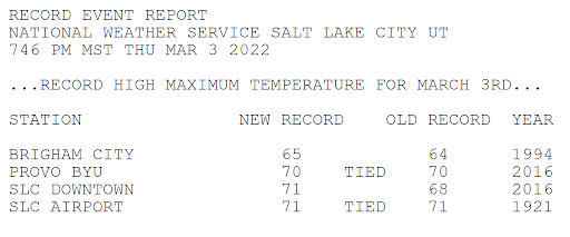
Some locations in Utah experienced the warmest temperatures of the year today, especially the central and south portions of the Wasatch Front Valleys. Spots around Salt Lake and Utah Counties even reached the low 70s! These highs were similar to what the St. George area experienced. 


In fact, it was record warm in Salt Lake and Provo. This is the record report issued by the National Weather Service:


Remember, spring doesn't arrive until March 20th! The average high/low temperature for SLC is only 51F/33F. 

Winter weather continues to be largely missing-in-action for the West. Mountain snowpack is generally not faring well at this point. At least, we appear to have a "little" help on the way. Not a blockbuster storm. I am anticipating cooler and wetter weather for parts of the Southwest/Great Basin this weekend. Good news! 

Here's the accumulated rainfall forecast for the next 7 days. Most precipitation will fall through this weekend. Utah could receive some of the highest precipitation amounts, with a separate system around the middle of next week boosting totals.


Converting liquid to snowfall for higher elevations (10:1 ratio), implies around 1 foot over the Sierras, and 1-2 feet in Utah's Mountains. Colorado may also do quite well. What about Utah's Valleys, including the Wasatch Front?

Gradual cooling is expected Saturday into Saturday night, with about half the precipitation falling as rain on Saturday. As the low crosses the area late Saturday night and Sunday, snow is expected along the I-15 corridor in Utah, from near Cedar City northward. And, some of the highest snow totals could fall across the northern valleys. Here's a look at the upper low track:


A deformation band (region of lift in the mid/upper atmosphere), north of the low center, could produce more intense rain/snowfall. Here's a look at moisture in the vertical, reading left to right at bottom, through time at SLC. Notice the more intense blue/purple colors "higher moisture" in the lowest levels early Sunday, as the deformation zone "or lift" is in over northern Utah.


Model ensembles are often useful when looking beyond a couple of days. These are multiple runs of the same model, giving a potential range of outcomes. What do the ensembles show for SLC? Focus on the green line, which is the average of all the runs. There will always be high and low outliers. I mostly ignore these individual runs. 


As you can see, the green "average" line of 24-hour snowfall produces about 2-3" for Salt Lake City Saturday night through Sunday. Not bad for a March storm, if it comes to pass. 

In addition, another storm is shown for Thursday of next week. This system appears a bit weaker, and fast moving. But, also colder with favorable NW flow. I can easily see a couple inches for the northern Utah valleys. Sorry southern Utah friends, this one will likely miss you! 

I will probably be unable to post for the next 10 days or so. Check the SLC Weather Service site for updated weather info! I also have links on my blog to road conditions and other resources. Have a great week, everyone! Fingers crossed for some decent mountain snow!

Thursday, February 24, 2022

Wintry Weather Ending in the West, and the Extended Forecast

It's been a cold, stormy week for parts of the West, including here in Utah. Most of the state saw some snowfall, including St. George, which saw periods of snow and sleet the last couple of days. The valleys south of Nephi did the best, with up to 6-8 inches in spots along the I-15 corridor down to Cedar City. Snow along the Wasatch Front was much lighter, but there were localized snow amounts up to 4-5 inches. Most of the lower Salt Lake and Utah Valleys had less than 2 inches. Here's a look at the 72-hour liquid precipitation amounts:  


You can see, the highest precipitation amounts were in the southern part of the state. Brian Head Ski Resort had about 3 feet of snow, impressive! Did this improve the snow water equivalent (SWE) values for the state this season?


Notice the green values (close to 100%) in the south half of the state. Not bad! This storm definitely helped the deficit. The northern half of the state, especially the Wasatch Mountains, are still at only roughly 75% of normal. More storms are needed! 

Are there prospects for snow in the near future? We have a weak trough moving across the north tonight:


It's a weak trough, and from a dry northerly direction. Temperatures aloft a quite cold, so there could be a little lake enhancement off the Great Salt Lake. It won't help the mountains much, but could bring light accumulations to some Wasatch Front Valleys through Friday morning. Here's a high resolution forecast model of snow accumulation:


Again, low level moisture is limited, but areas north of Salt Lake City to around Ogden could see 1-3 inches through midday Friday. Similar amounts in the mountains, perhaps up to 6 inches east of Ogden. 

We have one of the coldest mornings of the year on the way. Then, a ridge begins to build, with dry and gradually moderating temperatures into next week. 


Close to 10F at the SLC Airport Saturday morning, burr! 

So, will the dry pattern continue, or will we get more storms? Fortunately, looking about a week out toward the 4-5th of March, a snowy pattern could re-emerge. A trough could arrive around that time, off the Pacific Ocean, with decent moisture. 


Ensembles are a good tool to use looking at the extended forecast. The Euro model ensembles are 50 different "tweaked" runs of the same model, to account for subtle errors. This gives a better range of possible outcomes. What does it show for snowfall at SLC?


This chart can be a bit confusing, so let me explain. It reads left to right along the bottom. The green line is what you should follow, it's the average 24-hour snow amounts of the 50 runs. Notice the uptick around Friday-Saturday, March 4-5th. About 2 inches. Thick bars are ranges for most runs, with thin lines being outliers. Amounts could be slightly higher or lower. 

There is also more activity indicated for the following week. Potentially, more winter storms! 

What does the Climate Prediction Center (CPC) have to say? It appears they agree, the 8-14 day outlook calls for below average temperatures and slightly above average precipitation. 


Saturday, February 19, 2022

Winter Returns with Low Elevation Snow in Parts of the West

Since early January, the weather out West can only be described as, well-- blah! High pressure rules, with only occasional weak storms. This is in stark contrast to the wet, cold and snowy weather across the region last December. We need more weather! 

Well, I have some good news to share on that front. We have a couple of cold weather systems, that will affect areas from the Pacific Northwest to the interior West through at least the middle of next week. The initial system can be seen on water vapor satellite imagery moving into the Northwest today:


You can see the moisture trajectory coming from British Columbia. This means cold air will be driving into the West, along with precipitation. Because this system is not coming directly off the Pacific, the extent of snowfall across the West will be somewhat limited. The Sierra Mountains will largely miss out-- boo! 

Anytime it's cold enough for lowland snow in Western Washington, I get excited. Often, this portends good things for snow here in Utah. To get snow down to sea-level in the Puget Sound region, a high amplitude ridge is required over the East Pacific with a trough (usually) from the north. Here is the 500 MB pattern on Monday, showing this will be the case: 


It's getting late in the year for accumulating snow in the Seattle area, but I do think mixed precipitation is possible in heavier showers Monday. Those living on hilltops, along the Kitsap and Strait, and where a convergence zone forms (typically north of Seattle), could see a dusting on the grass. The Euro model agrees:


Generally, less than 1 inch. 

It will also be darn right cold for late February! Take a look at the forecast temperatures for Sea-Tac Airport:


Burr! So, where is this storm heading? 

It will actually move into the Great Basin/Southwest in two parts. The first system will reach the Wasatch Front Monday morning and push into the south part of the state later in the day. Some models show potential strengthening (referred to as "frontogenesis"), which could locally boost snow amounts. Here is a model simulation showing the main snow band and developing low pressure:


The Euro model forecast snow amounts for the first storm appear reasonable, shown below. Not a lot, maybe 1-2" in the valleys, a bit more benches, and ~6 inches in the higher mountains through Monday night. Similar amounts are expected further south along the I-15 corridor.  Expect the potential for snowy roadways if traveling in Utah on President's Day. Also, check the latest forecast from the NWS


The second storm system will track further south across Southern Nevada and Utah Tuesday through late Wednesday. Snow levels may fall as low as 2500 feet, meaning the outskirts of the Las Vegas Valley could see some flurries Wednesday. Yup- a few flakes could fly in higher spots like Summerlin and Henderson. However, don't expect any accumulation this late in the season. 

Other low spots may have better luck! The two main forecast models (GFS/Euro) indicate some accumulation is possible in St. George. Most guidance suggests around one inch could fall Wednesday, mainly in the morning. Here's what the Euro model shows for that region, including Las Vegas:


You can see some trace amounts around Las Vegas, and just over 1" in St. George through Wednesday night. The weather is always probability based, so amounts could be a bit higher or lower in St. George. This is several days out, so keep that in mind! 

The second system will likely hit the central and southern parts of Utah the hardest Tuesday through Wednesday night. Snow amounts south of Nephi could be significant, including Cedar City and higher locations like Brian Head Ski Resort. Amounts across Northern Utah will probably remain rather light, unless we get some lake effect kicking in. Check back as we get closer!

Finally, what about temperatures? Expect a big drop! Here's the NWS forecast for St. George: 


This is the forecast for Salt Lake City:


Expect moderating temperatures and a drying trend later next week! Have a great holiday, and travel safely!


A Vigorous Cold Front & Snow Expected Monday Night into Tuesday.

The current El Nino winter has brought plenty of precipitation to Utah. Most areas are above average on liquid water since October 1st, incl...