This blog is not for profit or political

Thursday, February 24, 2022

Wintry Weather Ending in the West, and the Extended Forecast

It's been a cold, stormy week for parts of the West, including here in Utah. Most of the state saw some snowfall, including St. George, which saw periods of snow and sleet the last couple of days. The valleys south of Nephi did the best, with up to 6-8 inches in spots along the I-15 corridor down to Cedar City. Snow along the Wasatch Front was much lighter, but there were localized snow amounts up to 4-5 inches. Most of the lower Salt Lake and Utah Valleys had less than 2 inches. Here's a look at the 72-hour liquid precipitation amounts:  


You can see, the highest precipitation amounts were in the southern part of the state. Brian Head Ski Resort had about 3 feet of snow, impressive! Did this improve the snow water equivalent (SWE) values for the state this season?


Notice the green values (close to 100%) in the south half of the state. Not bad! This storm definitely helped the deficit. The northern half of the state, especially the Wasatch Mountains, are still at only roughly 75% of normal. More storms are needed! 

Are there prospects for snow in the near future? We have a weak trough moving across the north tonight:


It's a weak trough, and from a dry northerly direction. Temperatures aloft a quite cold, so there could be a little lake enhancement off the Great Salt Lake. It won't help the mountains much, but could bring light accumulations to some Wasatch Front Valleys through Friday morning. Here's a high resolution forecast model of snow accumulation:


Again, low level moisture is limited, but areas north of Salt Lake City to around Ogden could see 1-3 inches through midday Friday. Similar amounts in the mountains, perhaps up to 6 inches east of Ogden. 

We have one of the coldest mornings of the year on the way. Then, a ridge begins to build, with dry and gradually moderating temperatures into next week. 


Close to 10F at the SLC Airport Saturday morning, burr! 

So, will the dry pattern continue, or will we get more storms? Fortunately, looking about a week out toward the 4-5th of March, a snowy pattern could re-emerge. A trough could arrive around that time, off the Pacific Ocean, with decent moisture. 


Ensembles are a good tool to use looking at the extended forecast. The Euro model ensembles are 50 different "tweaked" runs of the same model, to account for subtle errors. This gives a better range of possible outcomes. What does it show for snowfall at SLC?


This chart can be a bit confusing, so let me explain. It reads left to right along the bottom. The green line is what you should follow, it's the average 24-hour snow amounts of the 50 runs. Notice the uptick around Friday-Saturday, March 4-5th. About 2 inches. Thick bars are ranges for most runs, with thin lines being outliers. Amounts could be slightly higher or lower. 

There is also more activity indicated for the following week. Potentially, more winter storms! 

What does the Climate Prediction Center (CPC) have to say? It appears they agree, the 8-14 day outlook calls for below average temperatures and slightly above average precipitation. 


Saturday, February 19, 2022

Winter Returns with Low Elevation Snow in Parts of the West

Since early January, the weather out West can only be described as, well-- blah! High pressure rules, with only occasional weak storms. This is in stark contrast to the wet, cold and snowy weather across the region last December. We need more weather! 

Well, I have some good news to share on that front. We have a couple of cold weather systems, that will affect areas from the Pacific Northwest to the interior West through at least the middle of next week. The initial system can be seen on water vapor satellite imagery moving into the Northwest today:


You can see the moisture trajectory coming from British Columbia. This means cold air will be driving into the West, along with precipitation. Because this system is not coming directly off the Pacific, the extent of snowfall across the West will be somewhat limited. The Sierra Mountains will largely miss out-- boo! 

Anytime it's cold enough for lowland snow in Western Washington, I get excited. Often, this portends good things for snow here in Utah. To get snow down to sea-level in the Puget Sound region, a high amplitude ridge is required over the East Pacific with a trough (usually) from the north. Here is the 500 MB pattern on Monday, showing this will be the case: 


It's getting late in the year for accumulating snow in the Seattle area, but I do think mixed precipitation is possible in heavier showers Monday. Those living on hilltops, along the Kitsap and Strait, and where a convergence zone forms (typically north of Seattle), could see a dusting on the grass. The Euro model agrees:


Generally, less than 1 inch. 

It will also be darn right cold for late February! Take a look at the forecast temperatures for Sea-Tac Airport:


Burr! So, where is this storm heading? 

It will actually move into the Great Basin/Southwest in two parts. The first system will reach the Wasatch Front Monday morning and push into the south part of the state later in the day. Some models show potential strengthening (referred to as "frontogenesis"), which could locally boost snow amounts. Here is a model simulation showing the main snow band and developing low pressure:


The Euro model forecast snow amounts for the first storm appear reasonable, shown below. Not a lot, maybe 1-2" in the valleys, a bit more benches, and ~6 inches in the higher mountains through Monday night. Similar amounts are expected further south along the I-15 corridor.  Expect the potential for snowy roadways if traveling in Utah on President's Day. Also, check the latest forecast from the NWS


The second storm system will track further south across Southern Nevada and Utah Tuesday through late Wednesday. Snow levels may fall as low as 2500 feet, meaning the outskirts of the Las Vegas Valley could see some flurries Wednesday. Yup- a few flakes could fly in higher spots like Summerlin and Henderson. However, don't expect any accumulation this late in the season. 

Other low spots may have better luck! The two main forecast models (GFS/Euro) indicate some accumulation is possible in St. George. Most guidance suggests around one inch could fall Wednesday, mainly in the morning. Here's what the Euro model shows for that region, including Las Vegas:


You can see some trace amounts around Las Vegas, and just over 1" in St. George through Wednesday night. The weather is always probability based, so amounts could be a bit higher or lower in St. George. This is several days out, so keep that in mind! 

The second system will likely hit the central and southern parts of Utah the hardest Tuesday through Wednesday night. Snow amounts south of Nephi could be significant, including Cedar City and higher locations like Brian Head Ski Resort. Amounts across Northern Utah will probably remain rather light, unless we get some lake effect kicking in. Check back as we get closer!

Finally, what about temperatures? Expect a big drop! Here's the NWS forecast for St. George: 


This is the forecast for Salt Lake City:


Expect moderating temperatures and a drying trend later next week! Have a great holiday, and travel safely!


Tuesday, February 15, 2022

Colder With Snow Showers Tonight & Wednesday. Plus, Another Storm Next Week?

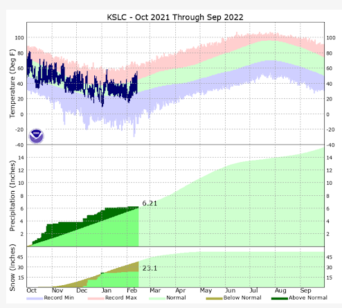
The weather pattern continues to disappoint this month, after measly January precipitation. It's hard to believe, but the Salt Lake Airport is still near average on water year liquid precipitation (Oct 1st 2021-Current). We've had some ups and downs with temperatures in the valleys, but we are generally running above average. Much of our seasonal precipitation fell in the months of October (when rain is more typical than snow in valleys), and in December, when the airport picked up almost all the snow that's fallen this season. Here's where we stand:


We should be near 38" at the Salt Lake Airport by this date, but we're only at 23.1", not great. More importantly, the lack of additional mountain snowpack is starting to get serious. As we move into March and April, average mountain snowfall trends start to decline. We are running out of time! Here's the latest snow water equivalent map (SWE) showing the decline to below normal across Utah and interior West as of today. We were well above normal at the start of January.


With that bit of bad news, we do finally have a chance of snow showers returning to parts of Utah tonight and Wednesday as colder air arrives. We may not reach out of the upper 30s Wednesday after hitting 60F at the Salt Lake Airport on Monday. First, here's a nice look at the water vapor satellite image (shows moisture, not clouds) with the 500 MB chart overlaid.


Those with a sharp eye might notice one obvious problem with the track of the upper low. Instead of diving south over Utah, the low is over Nevada/California. And the southern track is forecast to continue Wednesday. Here's what the Euro model shows:


While the main low tracks well south, notice a trailing upper trough (blue anomalies) hanging further back over Utah. This will be the weak system that ushers in colder air and limited moisture from late this evening through Wednesday. Since moisture and lifting of air is weak, snow showers should be light in nature. Here's a time-height of moisture in the vertical through time, reading left to right. You can see the deeper purples (moisture) developing.


Wondering how this showery pattern might evolve? The NAM model forecast simulated radar depicts this well. It runs from this evening through Wednesday PM. 


Not a lot of solid blue, and snow is scattered in nature. This will limit snow amounts in the valleys. The National Weather Service forecast is often based closely on the NBM (blended model) forecast. I think it looks reasonable. Less than 1 inch in most Wasatch Front Valleys, and a few inches in the mountains (locally 6" at higher ski resorts). Don't be surprised to see a dusting on the grass Wednesday morning. Not the type of snow amounts we need!


So, is there a still a chance of ending February with a stronger storm? There is a system advertised by models around Monday-Tuesday next week. But, models do not yet agree on whether this will be a stronger system, or another weak splitting trough. I'm leaning toward a weaker system, although it could still deliver a little more snow than the current system. This is the Euro 500 MB trough forecast early next week:


There's potential for a storm by Monday or Tuesday. The elongated trough implies it could split, and may form a cut-off low. Not my favorite set-up, but it can sometimes surprise. How the upper air pattern evolves will determine the impact of the storm on Utah-- Stay tuned! I will discuss what could be in store as we head towards March in my next post. 

Monday, February 7, 2022

Mountain Snowpack Declines in the West as Dry Weather Persists

A strong upper ridge continues to dominate just offshore, blocking moist storms from reaching most of the Western states. After promising December snowfall had boosted snowpack to well above average, January was a huge disappointment with well below average storm activity. This dry pattern has now extended through the first week of February 2022. And I see little change in the current pattern. Take a look at the ridge still sitting offshore, not good!   


There's been some weak systems bringing rain to the Pacific Northwest, but even that region has not seen particularly wet conditions in recent weeks. Take a look first at precipitation across the country as a percentage of average over the past 30 days: 


Clearly, below average precipitation the past 30 days over much of the West, and even Central parts of the country. How is snowpack faring? Here's the latest snow water equivalent map-- the trend since my last post is not good!


Some portions of the Great Basin region and Rockies are now as low as 60-70% of average, and many locations are nearing 85%. This means less water during the spring run-off flowing into our reservoirs, if we don't get more storms-- Not the trend we want to see. It could be worse. Generally, Utah ski areas are in fairly good shape. Here's the water year snowfall (Oct 1st 2021-current) at Alta Ski Resort:


Nearly 200 inches so far, about 50" short of average by this date. This is not terrible, but the gap appears likely to worsen.

Mountain snowfall averages start to decline in March and much quicker in April. If we don't get some moist storms in the West by the end of February, it is quite likely we will end another season with below average snowpack in much of the interior West, including Utah. 

So, do we have a chance of wintry weather returning for the second half of February? Sadly, the model trends are not promising the next 7-10 days. Little or no precipitation expected in Utah through mid-February. Temperatures will moderate in the Salt Lake Valley compared to last week's sub-freezing high temperatures, here's the model forecast at SLC:


Some longer range models have hinted at a possible shift westward of the high pressure ridge dominating off the West Coast. It needs to shift further out, south of the Aleutian Islands, allowing northwest flow to bring storms into the interior West. Here's the GFS ensemble 7-day average height anomaly for the third week of February:


Not promising either. The ridge and positive anomalies need to be further west, allowing the trough over the Central U.S. to shift over the West. Some models have shown some chance of this occurring toward the end of the month, but the signal is inconsistent and weak. I would say the chance of a major pattern change the last week of February is possible, but a fairly low probability. The latest Climate Prediction Center 8-14 day outlook is also pessimistic, mirroring my take on the pattern the next couple of weeks:


I hate prolonged drought patterns, so I thought I would end with a quick take on changes that are expected for next year's water season. This is the second winter in a row with the ENSO cycle being in La Niña phase. Historically, this does tend to cause blocking ridges over the Eastern Pacific, and cause variable jet streams. By summer, we will be heading into ENSO Neutral conditions, which has a good chance of persisting through next winter: 


Predicting the ENSO phase for the next season is not typically reliable until we reach the summer months. Forecasts improve greatly by that point. However, given that we just experienced a double dip La Niña, my bets are on Neutral ENSO conditions next winter. What does that look like for the West? Here's a 30-year average composite of temperatures and precipitation typical for ENSO Neutral winter months: 


Unfortunately, drier conditions are still common for California and the extreme south part of the Southwest (El Niño's tend to be wet for those areas). But, the signal for the interior West, including Utah, is generally for average winter precipitation. There's some reason to hope for better snowpack next year than this current season. 

And, just maybe, we will luck out with a wet 2022 spring, limiting drought severity this summer.


A Vigorous Cold Front & Snow Expected Monday Night into Tuesday.

The current El Nino winter has brought plenty of precipitation to Utah. Most areas are above average on liquid water since October 1st, incl...