This blog is not for profit or political

Friday, January 28, 2022

Pattern Change Busts in the West, and a Major Blizzard Back East

The big weather news is not currently about winter storms impacting the West. Rather, news headlines are focused on a Nor'easter (blizzard) forecast to slam the Mid-Atlantic and New England states. Given the storm's potentially high impact, I will discuss more details about this event in a moment. 

First, I don't have good news for those expecting a weather pattern change in the West. For weeks, extended range models were generally indicating a retrograding long wave pattern toward the end of January. I hoped a consolidated ridge would amplify further west over the Pacific, allowing for an active storm pattern over the Western states. Unfortunately, it now appears likely the ridge will remain too close to the West Coast, blocking moist Pacific storms. Here's the latest GEFS forecast upper height anomaly average for the first 10 days of February: 


There's broad consensus among the extended models that this pattern will dominate, even moving into the second week of February. Not good at all. Now, there is some westward shift in the major features expected, just not enough. Notice the ridge height anomalies offshore now extending inland to the Great Basin. Lower height anomalies are confined to the north/central part of the country. This pattern often leads to "clipper" systems tracking across the Northern Plains and upper Mid-West regions (minor snowfalls). 

The flow aloft over Utah and interior West, will come from a drier and colder northerly direction. Don't expect much warming here in Utah, but rather seasonable temperatures. A weak upper trough will move through from the north on Wednesday. Coming from an over land trajectory, this system will be moisture starved. Some models show a chance of minor snow accumulations, likely under 1". The NBM (model blend) forecast snow amounts on Wednesday look reasonable:


Not impressed? You shouldn't be. We need a lot more mountain snow if we want to end the season with just average snowpack. If the pattern doesn't improve in the coming weeks, our reservoirs are likely to end up in worse shape this summer than last year. 

Could the pattern become favorable for snow later in February? Short answer: I don't know. Extended range models are demonstrating poor consistency, and signal weak anomalies that don't point to a particular pattern later next month. 

Given the lack of weather in the West, let me discuss the Nor'easter that is forecast to slam parts of the East with blizzard conditions this weekend. Here is the water vapor satellite view of the storm, in the early phase of developing Friday afternoon:


The surface pressure is forecast to drop sharply tonight through midday Saturday, as the system rapidly intensifies. This storm fits the definition of a "bomb cyclone" (sea level pressure falling 24 mb in 24 hours). Some models show a sub 970 mb surface low just to the southeast of Boston, MA Saturday afternoon:


If pressures deepen anywhere near this low, there will be coastal flooding, and high winds coinciding with the heavy snow band shown above (blues/purples). Blizzard conditions are almost certain for near coastal areas of the Mid-Atlantic states to New England. The National Weather Service has blizzard warnings and numerous other hazard statements in effect for the region:


Northeasterly wind gusts will peak in the Mid-Atlantic states late tonight and in New England on Saturday. Here are the expected wind gusts near the peak of the storm's strength on Saturday, 60-70+ mph from Long Island to New England. High winds combined with heavy snow will lead to widespread power outages from New Jersey to Maine.


Snow amounts are forecast to be rather extreme, but not unprecedented. The heaviest snowfall across the region in years, for sure. There will be a tight snowfall gradient from lighter amounts to the highest amounts, possibly exceeding 2 feet. Greatest uncertainty of forecast snow amounts are from near Dover, Delaware to New York City (up to a foot possible). A slight shift in the track of the low could bring higher or much lower snow amounts within that corridor. Highest confidence in snow amounts are from Long Island to the coastal New England states. Here are the potential snow totals through the weekend:


Yes, you're reading that right. Portland, Boston, Providence, New Haven, and Montauk/Hamptons in Long Island could all see 2 feet of snow. Local amounts up to 30 inches are possible, especially at hill top locations like Worcester, MA. Snow of this magnitude has occurred in the past, but amounts over 30 inches are rare. This may not be a record-breaking storm, but certainly memorable (or historic) given the combination of hazards causing damage, travel impacts, and outages.

Wednesday, January 26, 2022

A Quick Update on Next Week's Weather Change

I still see the potential for a storm early next week, with snow in the valleys and mountains of Utah. As mentioned in the previous post, this could usher in a change to more active wintry weather. But, uncertainty has grown today in both the details and even the evolution of large scale features next week. A system is still expected to affect Utah next Monday and Tuesday. Details are still up in the air, so I can't yet offer specifics on potential snow amounts. Not yet! 

There was a shift in nearly all the latest models today, trending toward a stronger ridge closer to the U.S./B.C. Coasts next week. This is not good news for getting decent snowfall into Utah. Here is what the GFS 500 mb height anomaly looks like for the first 10 days of February:


Notice the ridge anomalies (yellows) reach the West Coast of North America and the long wave trough is centered further inland. This implies storms could arrive from a northerly land trajectory, southward through BC. These nearly always lack moisture, and disappoint with snowfall. The only positive, is that precipitation would likely fall as all snow in the valleys. Amounts are likely to be on the low-side...If the large scale pattern evolves in this manner.  

A different model, the Euro EPS ensemble (50 runs of the same model, "tweaked" for different potential outcomes) is also pessimistic. Reading along the bottom, from left to right, you see the average daily precipitation value through the 10th of February. Not impressive, not at all-- right!  These amounts are much lower than what models showed the past couple days. I would not put too much faith in this particular run.


So, let's wrap this up on a positive note! Models continue to be quite volitile. A lot of variability and poor run to run consistency simply screams the message-- Uncertainty is very high! I do believe models will come into better agreement over the next couple days. Enough so, for another update toward the weekend. Check back!

I will end with the GFS ensemble of 30 runs. It still shows snow accumulation early next week. Not much, but there's potential. Fewer members indicate snow beyond a week, but you can see the chance is still there.


A Potential Return to Winter Weather Next Week

We finally have the makings of a weather pattern change in the West, starting early next week. The past few weeks, I have discussed the potential for a retrograding long wave pattern toward the end January into early February. Indeed, it appears this shift will soon be underway. In the world of weather forecasting, nothing is ever simple. Hence, the accurately coined phrase "weather is an imperfect science". While I believe changes are on the way, aspects of the extended outlook are still rather merky. I will get to that in a moment. 

Let's first check up on mountain snowpack as we near the end of a relatively dry month. Good news first. Thanks to blockbuster mountain snowfall in December, snow water equilvalent (SWE) values are still in decent shape. Although storms were lacking much of January, SWE values are still close to normal in most regions, as of January 25th. Southern Utah, and Southern Nevada are well above average. While, Colorado and Wyoming are not faring as well.  


It's best to measure progress using the water year calendar, which runs from October 1st to the end of September the following year. This allows us to visualize the seasonal data. Let's take a closer look, starting with the Alta Resort measurent site. They maintain good records. How has the snowpack progressed since Oct 1st 2021? Here's the data:


The brown line is average snowfall from October 1st to current date. Green is accumulated snowfall. Alta has had 192.9" so far, not far below the average of 218.2". Highest on record is blue, and red is lowest. 1983-1984 had some crazy extreme snow up to this point! What does average yearly snowfall (by month) look like for Alta: 


The bar graph shows the best snow months are Dec-Jan-Feb, with March not far behind, in 4th place. Point being, we still have a couple of the best months for mountain snow to come. What about the valleys? Here's the liquid precipitation and snowfall at the Salt Lake Airport for the water year to date:


Surprisingly, the airport still has above average precipitation, for the water year to date. However, SLC snowfall only stands at 22.1" to date, almost all of which fell in December. A normal year would have 30" of snowfall by this point in the year. 

Let's see if we can do some catch up, alright! Here is the Climate Prediction Center's 6-10 day outlook. For the interior West, near to above average precipitation and colder than average temperatures. They also believe a pattern shift will occur by early February! 


This season has featured some huge monthly flip-flopping extremes in temperatures and precipitation.  It just so happens, the storm-blocking high pressure ridge near the West Coast, will begin a westward shift.  I hope this will open the door to storms arriving from the northwest. Look at the 500 mb trough anomaly for the first week of February:


This particular GFS model develops a long wave trough over the West. Think of the upper height anomalies (deep blues) as a region where storms are likely to be active. Looks interesting! 

I have a word of caution here, listen up! Not all models agree on the strength and location of the big weather influencers come early February.  Uncertainty is quite high!  We could get a short window of active weather, or set up a pattern favorable for a series storms. Hopefully, the latter. 

That said, I am watching one storm of interest, expected to reach Utah early next week. It arrives from a cold trajectory, so I would expect mostly snow in the valleys (except far south). In fact, much of the state could get some decent snow including the mountains-- you're welcome skiers!  It's way too early for further details. Just know there could be appreciable snowfall around Monday-Tuesday next week. 

Below is projected precipitation accumulation through the 10th of February at the SLC Airport. There is minimal skill that far out, so only focus on the trend. Notice the green line (mean of 30 model runs) trends upward around next Monday-Tuesday through the first 10 days of February. A potentially wet/snowy period in Salt Lake City, and possibly much of the state and surrounding region.


Wednesday, January 19, 2022

Snow Expected Friday, and a Potential Wintry Extended Outlook

We finally have a weather system to discuss, which is expected to reach Utah on Friday. Yippee! Before we get to the details, let's take a look at the current stagnant pattern. 

We have a strong ridge centered just offshore, providing sinking air over much of the interior West. Notice the ridge is positioned a little further westward than several days ago, something is changing! 


This stagnant air mass and resulting valley inversions are creating poor air quality, mostly in the moderate category-- unhealthy for sensitive groups. This may continue into Thursday, but we should see a vast improvement Friday as a relatively weak storm arrives.


Now that the ridge has shifted from the interior West to just offshore, the door is open to a system arriving from the north. Systems that arrive from the northwest, off the Pacific Ocean, tend to be associated with good moisture content. In this case, the Friday system will come from the north, moving over more land mass and with less moisture. There is a plus here-- it should be cold enough for precipitation to fall as all snow in the Wasatch Front Valleys. Here's what the 500 mb trough looks like Friday morning:


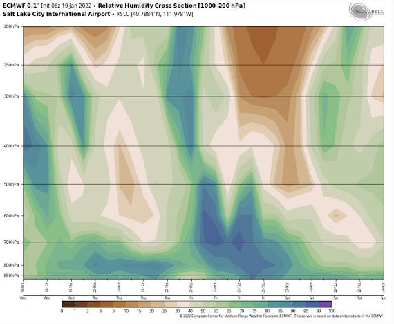
 ...And moisture? Below is a time-height forecast at SLC of the moisture in the vertical, through time, reading from left to right. Deeper blues or purples show high relative humidity values, a measure of saturation in the atmosphere. Browns/lightest greens are drier air. Notice the deeper blue colors start off at 700 mb which is roughly 4-5k above ground level at SLC, and drier near the surface. There could be some flurries or very light snow prior to 5 AM (12z) Friday, but not yet significant. After 5 AM, the brighter colors reach more toward the surface indicating the low levels are moistening up. Expect snow to pick up across the Salt Lake Valley at that time! By late Friday morning, moisture decreases and so will the snow, becoming dry by the afternoon. 


This is a quick moving storm and with limited moisture. But, I do expect snowfall along the entire I-15 metro corridor from Nephi to the Idaho border. Remember, the front is coming from the north, so Logan to Ogden will see accumulating snowfall 2-3 hours earlier than the Salt Lake Valley. From Utah county southward (Provo to Nephi), expect snowfall to start 1-2 hours later. So, we all want to know how much snow will accumulate right? Here is the NBM (model blend) forecast for expected snow and I think it's reasonable:


It shows 1-2" for the I-15 metro corridor, including the Salt Lake Valley, which is very reasonable. The benches could see 3" (light blues). Higher mountains and ski areas, up to 6". This is not a blockbuster storm, but it is a stagnation-busting storm. It will clear out valley inversions and pollution. Better yet, it will provide a little fresh powder for the ski resorts-- you're welcome skiers! 

Expect snowfall during the Friday morning commute. It could get a bit messy but probably not high impact overall. Temperatures in the lower valleys should be in the low 30s, so roads will be more slushy than icy. Conditions will still warrant driving with caution. Roadways near the benches and in the canyons could be especially snow covered and slick Friday morning-- be prepared! Check the most recent/updated forecasts as we approach Friday weather.gov/SLC

So, can we expect more of the white stuff anytime soon? For at least the next week (except Friday), probably not much. However, the larger-scale pattern change I discussed in previous posts still looks very possible-- great news! I have closely tracked the longer range models for a couple weeks now. They have waffled a lot from day to day, but still generally show the long wave trough currently over the Eastern U.S. retrograding to the West toward the end of this month. Remember, a long wave trough is a region where there tends to be active wintry weather, not indicative of any specific storm. I'm sure most of you have seen pictures on TV of the snow and ice the past couple weeks affecting the Eastern states. Blame the longe wave trough! 

So, what does the long wave pattern look like for the next several days? Here are the 500 mb height anomalies showing the long wave trough will still reside over the Eastern states. It does not mean we will not see a storm in the West. In fact, we expect a weak one to reach Utah on Friday. The main storm track is simply, on average, over the East.


Blue colors above indicate lower height anomalies (trough), so expect more winter weather in the Eastern U.S. this next week. The ridge anomaly is just off the U.S and B.C. coasts, too close for large or successive storms. But this is expected to change. Take a look at the long wave pattern toward the end of the month:


Notice a difference? The trough anomaly back East is weaker, hence the light blues. More importantly, the high pressure anomalies have shifted further westward and extend north into Southwest Alaska. That's why I refer to this as a retrograding long wave pattern. The large weather influencers are shifting westward against the prevailing flow of individual weather systems that move with an eastward component. By the last few days of January, the 500 mb lines on the map are northwesterly oriented and the ridge is further west which is conducive for a storm track into the Great Basin, including Utah. It gets better! Here are the low height (trough) anomalies for the first week of February:


This is a great long wave set up for wintry weather in the West. The ridge is amplified and far enough offshore to drive colder air south from Western Canada. Storms moving into the Pacific Northwest would reach Utah, and with good moisture content. Significant mountain and even valley snow is possible, but those details will have to wait until we get much closer in time. Much of the Western U.S. would also experience unsettled wintry weather if this pattern develops.  Again, we're not looking at any specific storm this far out, just the pattern. It is entirely possible to have a long wave trough over the West, under a poor flow regime, and not get strong storms here in Utah. So, stay tuned! 

Here's one last graphic, showing the Euro model ensemble forecast (snow amount at SLC) that extends into the first couple days of February. The ensemble is 50 "tweaked" projections of the same model all at once to account for possible errors and outcomes. Pay attention to the green line (average of all runs) at the bottom, reading left to right. You can see the average green line shows less than 2" at SLC Friday morning. There's a hint of a very weak system around next Tuesday but even less significant than the Friday system. Check out the green line moving up the last couple days of January into the first few days of February. Don't pay attention to the actual snow amounts that far out, there is no skill! It does imply the average of the 50 runs show storm activity picking up over our area. Given that January will likely end with below average precipitation across Utah, let's hope for a more wintry start to February!   


A Vigorous Cold Front & Snow Expected Monday Night into Tuesday.

The current El Nino winter has brought plenty of precipitation to Utah. Most areas are above average on liquid water since October 1st, incl...