This blog is not for profit or political

Saturday, February 24, 2024

A Vigorous Cold Front & Snow Expected Monday Night into Tuesday.

The current El Nino winter has brought plenty of precipitation to Utah. Most areas are above average on liquid water since October 1st, including the Wasatch Front Valleys. Mountain snowpack is well above 100% of average across the state. 

Mild temperatures have kept much of the valley precipitation in the liquid form, unlike last year. Snow has been hard to come by in the valleys with an active mild southern stream jet. Only 2.2" of snow has fallen at the SLC airport this month (10.7" avg month of February). As you can see, snowfall since start of the October 1st water year is running less than half of normal: 


I fully expect to end the valley snow season well below average even with above average rainfall. But, we can certainly add to our meager seasonal snow amounts at SLC! Here's a look at the jet stream forecast Monday 5pm:


You can see a cold polar jet driving a low-pressure system from the Pacific Northwest into Utah. A sub-tropical jet will be pumping moisture into Utah ahead of the cold front. This will add juice to our storm! You can see Precipitable Water will reach near 200% of average as the front approaches Monday evening:


Models remain very consistent in showing a vigorous surface front with sharp temperature gradient. Any brief rain will quickly change over to snow sometime after midnight Monday night. There is a bit of uncertainty with timing. But good agreement on a strong front as seen using the 850-700 mb thickness values-


With the milder moist air in place as the front pushes through, strong lift should produce 2-3 hours of moderate to heavy snow. We could also get some thunder as the front moves through, maybe thundersnow!! As for amounts, 2-4" of snow seems like a good early estimate for most valley locations. Slightly higher along the benches. This is a fast mover which will limit larger accumulations. 


There is some question regarding possible lake effect and if that will add to amounts through Tuesday evening. It's just too soon to know yet but watch the forecast! Be prepared for slippery road conditions for the Tuesday morning commute.


Monday, February 19, 2024

Another S.W. Atmospheric River this Week. A Colder Storm Possible Next Week.

Here we go again! Another El Nino driven storm is delivering copious amounts of rain and mountain snow to California.  Other parts of the interior Southwest and Rockies will benefit as well. 

Looking at the water vapor satellite image allows us to easily visualize the upper flow pattern. Strong low pressure is centered off the Northern California coast. You can see the sub-tropical moisture tap into the Southern part of the state. Many flood warnings are in effect. 


Precipitation is also spreading inland. Rain will reach the Wasatch Front this evening and snow will become heavy in the mountains.


Periods of valley rain and mountain snow will impact Utah and Colorado the next few days. Wet news is good news out West!

A check on mountain SWE (snow water equivalent) that feeds the Colorado River Basin reveals we are generally near to slightly above average across the Basin. Only SW Wyoming is lacking a bit. Green colors are near average, the blues are above and reds below. Classic El Nino pattern with below average snowpack in the Pacific Northwest. 


How much rain should we expect through Thursday? Here's the model blend total liquid precipitation forecast through the end of the work week:


Red colors are 2+ inches. California coastal and mountain areas could receive localized amounts over 4 inches, impressive! That's on top of rain that has fallen already. Let's zoom in on Northern Utah:


Wasatch Front Valleys favored by SW flow will get the higher rain amounts. Provo and Orem will probably receive over 1+ inches the next few days. Locations that shadow in SW flow, will see less. This means much of the Salt Lake Valley (central/south) will be more in the 1/2 to 1 inch range. 

Translating to snow for the higher mountains gives about 1-2 feet, with 3+ feet in parts of the upper CottonWoods. Check the road report before traveling in the canyons.

El Nino is typically mild given the active southern jet stream. That pattern will keep precipitation mostly in the form of rain for the valleys this week. Take a look at the temperature forecast for Salt Lake City:


Notice the dip in temperatures early next week? Well, it's still a way's out but a colder storm could bring some valley snow before heading into March. Here is the forecast upper air pattern on Tuesday the 27th:


The GFS shows a cold upper trough arriving from the Northwest. A good trajectory for most Wasatch Front Valleys. Models are not all in agreement, with the Euro showing a weaker and faster moving storm, so stay tuned! 

It's often helpful to check the ensembles, which are many "tweaked" runs of one model. In the case of GEFS, it is 30 runs plus one primary control run. Extended forecasts are simply better if you look at the average of possible outcomes. This is the latest output for Salt Lake City:


Again, this is very far out. Don't focus on exact amounts. Follow the green line which is a running 24-hour snow accumulation at the SLC airport. It shows perhaps two waves of snow, one with the front late Monday and a follow-up wave late Tuesday. This could deliver decent valley snowfall but let's not get into specific numbers yet. 

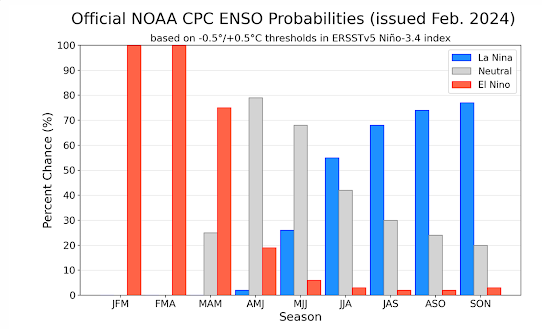
Finally, I should note that El Nino is waning and a transition to neutral conditions are expected by summer. Of interest, the CPC (Climate Prediction Center) is forecasting a good chance of La Nina conditions next fall/winter. While ENSO is a poor predictor for precipitation, I would generally expect lower snow levels next winter season across Northern Utah.


A Vigorous Cold Front & Snow Expected Monday Night into Tuesday.

The current El Nino winter has brought plenty of precipitation to Utah. Most areas are above average on liquid water since October 1st, incl...